The Wrack
The Wrack is the Wells Reserve blog, our collective logbook on the web.
The Wrack is the Wells Reserve blog, our collective logbook on the web.
Sanford, the town with York County's largest population, contains the headwaters of these five rivers:
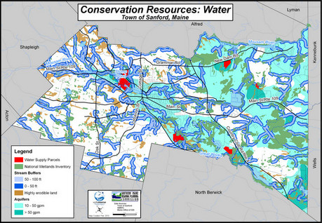
The headwaters of these five rivers are less than a day's journey to three estuaries in two states. Land use in Sanford affects waters that drain to two National Estuarine Research Reserves, a National Wildlife Refuge, and significant wildlife habitat managed by the Maine Department of Conservation and The Nature Conservancy. Two of the watercourses — Branch Brook and the Salmon Falls River — form public drinking water supplies. The Maine Department of Environmental Protection lists four of the rivers on its priority list for nonpoint source pollution due to contamination or vulnerability as source water.
When the town decided to create a conservation plan to help protect its regionally important water resources, they contacted the Wells Reserve for our expertise in land conservation, community outreach, and natural resource management planning.
Sanford, recognized importance of balancing conservation and development inorder to reach the goals identified in it's current comprehensive plan. Its growth is slow but steady as people discover the advantages of living near a regional center in a beautiful part of the state. As the need for housing and services increases, the farms, woodlands, and rural lifestyle associated with Sanford were in danger of being lost.
During the spring and summer of 2008, the Wells Reserve hosted a series of three workshops in Sanford to solicit community's vision for the future. Sanford residents were joined by people from neighboring towns, land trusts, state government, the water district, and conservation groups, helping them to extend conservation thinking beyond town boundaries.
The workshops used two decision-making tools, Community Viz and Keypad Polling, to engage community members in identifying conservation priorities. The results were used to construct the conservation plan that outlines goals and strategies for protecting the natural areas and working landscapes of Sanford.
Headwaters establishes science-based conservation strategies to meet the conservation goals identified in the Sanford Comprehensive Plan while achieving Sanford's goals for economic development. It highlights the importance of green infrastructure, the idea that natural places and working landscapes provide services — clean water, working farmland, wildlife habitat, flood control, natural beauty — that should be valued as assets when communities are planning for growth. The plan…
On July 1, 2009 the Planning Board voted unanimously to accept Headwaters, A Collaborative Conservation Plan for the Town of Sanford as an amendment to its Comprehensive Plan. Adopted as policy, Headwaters will guide future land use decision-making in this forward-thinking town.
Download Headwaters: A Collaborative Conservation Plan for the Town of Sanford (12 MB)
Headwaters was developed by the Wells Reserve and Southern Maine Regional Planning Commission in collaboration with these regional conservation partners: